

As the NUSSU ISB man, I asked the NUS administration to let me see the past routings of the buses, so I knew what to propose and what had already been tried and rejected.
They took quite a while to get back to me. Not their fault, they were probably busy. There are quite a lot of things going on in their areas this year, and they had more urgent things to do.
But I had nothing better to do. So after a bit of inspiration (and a lot of free time) I ended up going to the Wayback Machine and digging the maps out myself. I managed to find routings as far back as 2002, and it turns out some of the services have changed a fair bit. This explains why if you ask seniors, they may have memories of vastly different bus routes.
So this is the first in a multi-part series on the history of ISB routes. In this one, I’ll focus on the history of routes D1 and D2, which have the most interesting history of all the ISBs.
Supplementary Service
The D routes had their beginnings on 6 January 2003, as a supplementary service that ran only during the school term. At the time, there were only three services running around campus: A (1 and 2), B and C. Each had their own plastic signboards: A1 was red, A2 yellow, B was green and C was blue.
The supplementary service was introduced without any route letter; perhaps the school was unsure of whether it would become a permanent fixture. Instead of a large plastic sign, buses carried long white pieces of paper that looked handwritten.
This service was aimed at providing better coverage to the western half of campus, from Business School to Faculty of Science. Note that at the time, Kent Ridge MRT was not yet built so Central Forum (the CLB area) was the key transport node. I presume it was intended to “supplement” A1 and A2 during certain peak timings.

This is the route of the supplementary service as indicated on the website in 2004.
An update to the website in late 2005 provided better clarification on the nature of the service, and indicated the bus stops in both directions.

First Generation Route Map (2004-2007)
Before 2007, bus route maps on the OCA website were simple GIFs consisting of red lines drawn over an ancient-looking map of NUS. This is the map for the supplementary service:

Second Generation Route & Map (2006-2011)
From AY06/07, the supplementary service was upgraded to a permanent service D, and gained permanent plastic signboards. It still ran during term time only, but had much better frequency (5 to 7 minutes throughout the day).
Service D was now coded black, and the boards featured black text on a white/silver background.


Instead of GIFs, NUS now uploaded proper PDFs that put the route over a clearer and updated campus map, as the second generation of route maps. This is what the route map for D looked like:

Sharp-eyed viewers will notice that the arrows are inverted — Singapore drives on the left, but the arrows seem to go the other way round. This was probably just the equivalent of a typo. Otherwise, the route displayed is exactly the same as the supplementary service.
As for the stops served by D, minor additions were made. At the start of AY06/07, alongside the “promotion” of the service, Opp University Hall and University Hall were added. Later, during winter, SoC1 (today’s S17) was added.
Third Generation Route & Map (2011-2013)
This is where things start to really heat up for D. In AY11/12, after UTown had been opened, NUS decided to make service D serve UTown, so it would pop in and out of OED and UTown twice in a single trip. The other changes were that the new D also served COM 2 in both directions, and ran during vacations as well.
The route was thus split into D1 and D2, but the terminal and looping point was the same. It still started at Carpark 11 (behind BIZ) and looped at Science.

Buses leaving BIZ towards Science were known as D1, and after turning at Science they would flip the board around to show D2 heading back to BIZ. This would avoid confusion at OED/UTown and COM 2 over which bus to board.

Interestingly, despite the HSSML bus stop shifting to BIZ2 in early 2007, these 2011 route boards continued to show “HSSML” as the end of the route. Note also the hyphen in “U-Town”.

This meant that D1 was the anticlockwise route and D2 was the clockwise route. I would have preferred if it were the other way around, to standardise with A1/A2. But they probably just did it that way so the bus would start as D1 and end as D2.
NUS slightly redesigned all the route maps during this time, forming the third generation. Mostly it just involved changing the font to a rounded font (why though…). Below is the map for D, now split into D1 and D2.

This routing, of course, was a burden to the drivers. D was now one of the longest routes to operate. Large numbers of buses had to be added to the fleet to maintain frequency, causing controversy as residents of KE7 and PGP felt marginalised by what they saw as NUS focusing too much on serving UTown.
It was also very inefficient. Being a long loop, bunching would occur very easily. New buses had to be pumped in as D1 from BIZ, resulting in long D2 “trains” on the way back with large gaps in between.
Split into Separate Loops (2013-)
In AY13/14, NUS recognised the inefficiency of this setup, and decided to split up D1 and D2 altogether. D1 and D2 were no longer reversed directions of the same route, but split into different routes entirely, travelling through different areas but starting and looping at the same place.

This route map, demonstrating the butterfly shape somewhat, would still be considered a third generation map for me based on its era and design. One thing to note is that, although D2 started and ended at PGP, it still parked and had layovers at Carpark 11 and not at PGP.
Plastic boards were still printed, but used increasingly rarely as buses with electronic signage came in. By this time, the boards printed were half-sized to accommodate the pit in the Scania K230UB windscreens.
D1’s board retained the black-on-white colouring, something I was not aware of until after 2019. Since D1 stopped at COM 2 twice in one trip, the direction indication on the board was important. One direction displayed “OPP. HSSML > COM CEN > UTOWN”, while the reverse direction was “UTOWN > CTRL LIB > BIZ2”. Note that the hyphen has been dropped from “UTown”.

Meanwhile, the D2 board was light purple in colour, and depicted D2 as a service between “PGPR” and UTown (yes, it says PGPR both ways).
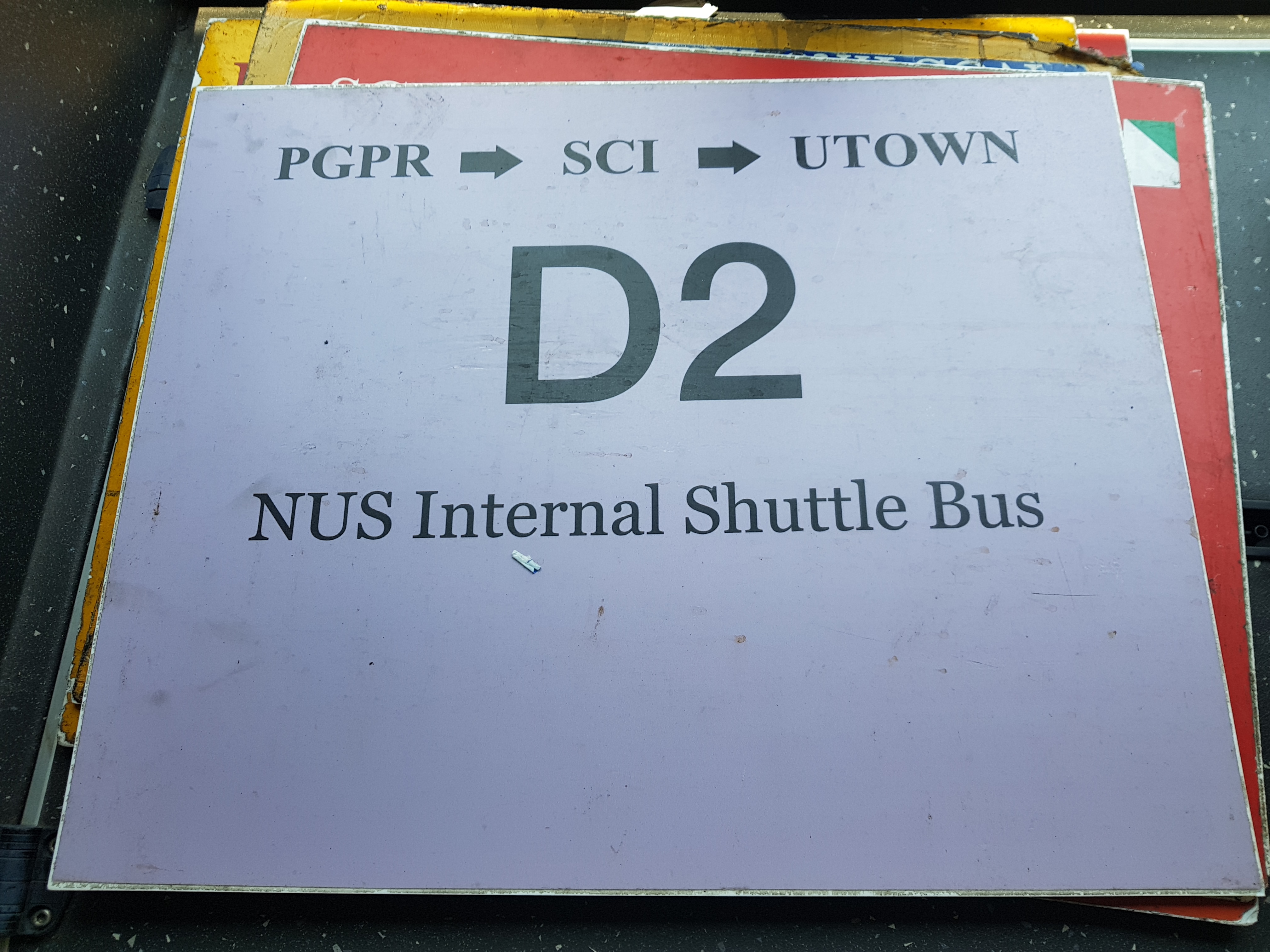
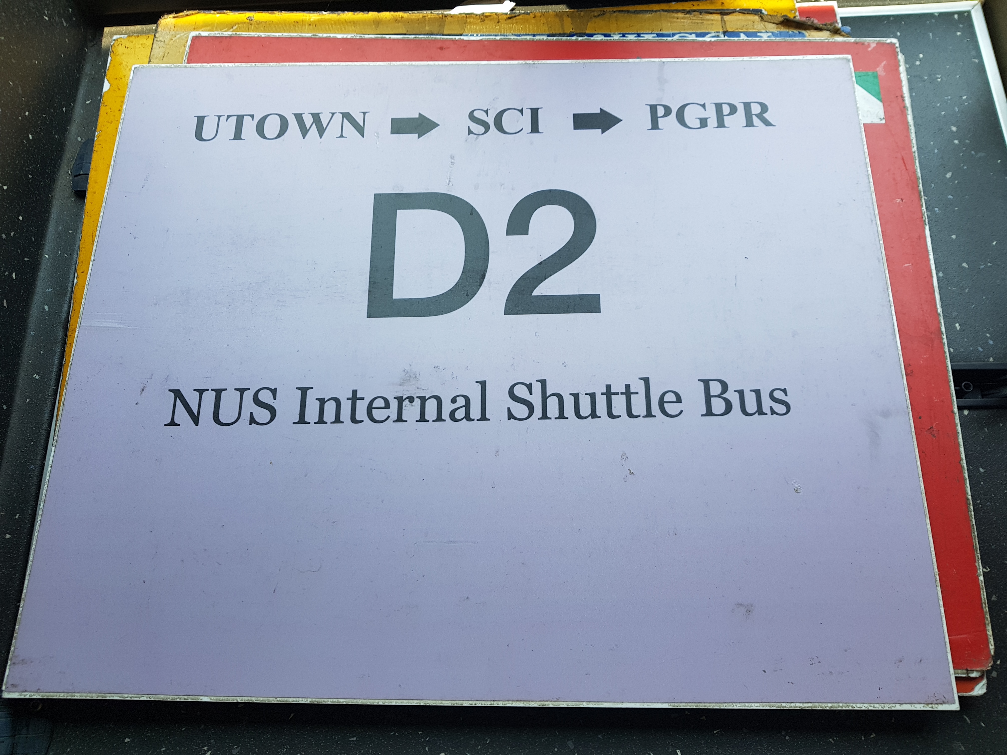
D1 would now cover the western side of the campus, shuttling students between UTown and FASS, SoC and BIZ. D2 covered the eastern side of the campus, shuttling students between UTown and FoS/Med as well as Kent Ridge MRT. The lack of direct connection between UTown and KR MRT was finally addressed.
Some D2 trips throughout the day ran as UT-FoS Direct buses. These trips came from the D2 lineup, but only stopped at UTown and Faculty of Science.
For the UT-CLB Direct buses, they will be covered in the Service B article as they were ultimately folded into the B route.
From there on, it was only a matter of minor tweaks to the routes.
On 29 September 2014, D2 was extended to serve Carpark 11 as a bus stop as a trial measure. This actually just meant allowing passengers to board at PGPR, and to remain on the bus until Carpark 11. The Carpark 11 bus stop was in fact a couple of parking lots paved over with concrete to become an alighting area, and was conveniently located near BIZ2.
This became official (permanent) on 3 November 2014. It was a good move IMO as it allowed passengers from KR MRT to take D2 to Business/Computing, relieving demand on A1. The first stop of D2, however, remained as PGP.
This allowed D2 to supplement A2 from Science to Business – the other half of the circle, if you consider the original route of Service D, which supplemented A from Business to Science!
On 1 August 2015, D1 was amended to stop at Museum after UTown instead of before, while D2 was unchanged. This was unpopular and soon reverted; D1 was back on the original routing on 7 March 2016.

Around this time in 2016, NUS also simplified the digital display from “BIZ>SoC>FASS>CCE>UTown” and “UTown>Museum>CLB>FASS>SoC>BIZ”, to simply “BIZ>UTown” and “UTown>BIZ”.
This aided in identification of the bus at COM 2. Since 2013, the buses going both ways at COM 2 are both called D1. So students have to look at the words unlike other services. The simplification helped students easily see which direction the bus was heading.
Fourth Generation Map (2016)
Around 2015-2016, NUS redesigned their route maps for a fourth generation.

The fourth-gen maps, in particular, show the amendment to Service D2 ending at Carpark 11.

The UT-FoS Direct route also had a map.

Fifth Generation Map (2018)
Following a meeting with NUSSU in 2018, OCA realised that the fourth-generation maps had been lost from their website. Based on NUSSU’s feedback, they not only dug out the maps but added the stops onto them, forming the fifth generation of maps.


Our maps, as seen above, are now more user-friendly, although the colour contrast is a bit of an issue.
New Developments (2018-)
In 2018, following NUSSU feedback, the font size of the display was increased for D1 and BTC1/2. In the same year, the UT-FoS trips were discontinued and merged into D2 trips, as C was amended to enter UTown thus serving the UT-FoS demand. NUSSU tried to have it retained, but the office declined, citing resource constraints and an oft-quoted fear of having too many bus routes at the UTown stop.
May 2019 saw a significant change to Service D2: it was altered to begin at Opp TCOMS (one stop prior to PGP) and end at TCOMS instead of Carpark 11. This was because of the impending closure of Carpark 11, to make way for COM3 construction work. With this, students lost a direct link from Opp KR MRT to Business, but now they could alight at TCOMS and change to an A2 without any walking needed.
As such, the map was edited to reflect the new start and end point. The below map is the latest D2 map as of 2019:

COVID-19 Suspension (2020)
Due to the COVID-19 pandemic, students had to be segregated into zones to minimise the chance of cross-infection across different faculties due to NUS’ connected nature. As such, ISB routes were revised and replaced from 20 July 2020 to facilitate zoning, and all existing services were suspended for AY20/21 Semester 1. The service names were not reused.
Reinstatement (2020)
On 6 December 2020, following the lifting of the zoning policy, the original pre-zoning routes were reinstated.
Network Amendment (2021)
As part of the New ISB Network introduced on 19 July 2021, Services D1 and D2 were to be amended. On 19 July itself, there would be no change to Service D1 itself, as its amendment depended on the opening of COM 3. As COVID-19 restrictions caused delays to the opening of COM 3, Service D1 retained its previous routing on 19 July 2021 when the rest of the New ISB Network began service.
Meanwhile, Service D2 was truncated from 19 July 2021 to start at PGP and end at PGPR (later PGP Foyer), effectively reverting it to its 2013-2014 routing (before even the extension to CP11). The change was made to shorten the route and enable the buses to layover at PGP. Service D2 no longer needed to serve TCOMS as the amended Service A1 and A2, no longer breaking for layovers at PGP, played the role of directly connecting Business and TCOMS with Kent Ridge MRT.

With this change, D1 and E formed the CP11 route group, while D2 moved over to join K in the PGP route group. A1 and A2 had shifted from the PGP group to the KR Bus Terminal group.
Sixth Generation Map (2021)
In tandem with the New ISB Network, Service D1 and D2 received new maps. A new sixth-generation route map was introduced, featuring the routes overlaid on an updated black-and-white map of the Kent Ridge Campus.
D1’s map in July 2021 displayed the D1 route with no changes, but the route was coloured pink in keeping with the network map colour.

Service D2 got a sixth-generation map as well reflecting the change; with the new map, Service D2 was now consistently coloured purple on all system and network maps.

EDS changes (2021)
While Service D1 did not immediately get amended on 19 July 2021, the EDS was updated to simplify the display for commuters. Previously, the two halves of the route were denoted as “BIZ>UTown” and “UTown>BIZ” to enable commuters at COM 2 to differentiate the direction. However, we still got feedback that the display was confusing. Some commuters bound for UTown decided to step aboard “UTown>BIZ” buses, believing that the bus was headed for UTown next!
As a result, since the rest of the routes were being reprogrammed, NUS changed the display specifications to simply “TO UNIVERSITY TOWN” and “TO BIZ 2”.


Service D2 also had its EDS amended in 2021. Previously, the text shown had been “PGP>KR MRT>FoS>Museum>UTown (Loop)”, but to standardise with the other routes, it was replaced with “PGP>KR MRT>UTOWN>OPP KR MRT>PGPR”, removing the “Loop” nomenclature.
In the New ISB Network, D2 was the only service beside D1 with a clear looping point (UTown).

D1 Amendment (2022)
In July 2022, the COM 3 building was finally ready. As such, the previously-deferred amendment to Service D1 was implemented on 25 July 2022.

The amended route of D1 would see it skipping COM 2 entirely, eliminating the pesky double-stop that forced commuters to read the EDS on the bus to distinguish its direction. It would instead serve SoC commuters at the COM 3 bus stop, ie. the former Carpark 11 which would now become the formal start and end of Service D1.

As D1 no longer needed to distinguish its direction at the same stop, its EDS could now display one string for its entire route: “COM 3 > IT > UTown > CLB > COM 3”. The map of the service was also updated.

In June 2023, with the tweaking of some EDS colours, D1’s shade was further lightened, resulting in a new map with black text.

D2 Amendment (2023)
From 16 October 2023, as Car Park 13 was closed to make way for the Executive Centre, NUS ISB A1 and A2 were amended to skip the detour into COM 2. To provide SoC with access to PGP, Kent Ridge MRT and FoS, D2 was extended into COM 3.


That’s all for the history of service D. As you can see, it certainly came a long way from being a supplementary service. Stay tuned for the other routes!
Further Reading:
All Episodes
- History of Bus Routes Ep 1: D1/D2
- History of Bus Routes Ep 2: B1/B2
- History of Bus Routes Ep 3: C
- History of Bus Routes Ep 4: A1/A2
- History of Bus Routes Ep 5: BTC1/BTC2
- History of Bus Routes Ep 6: A1E/A2E
- History of Bus Routes Ep 7: HMK1
- History of Bus Routes Ep 8: AV1
- History of Bus Routes Ep 9: AA1/AA2
- History of Bus Routes Ep 10: BB
- History of Bus Routes Ep 11: CC/CCX
- History of Bus Routes Ep 12: DD1/DD2
- History of Bus Routes Ep 13: NUS Direct Lunch Shuttle
- History of Bus Routes Ep 14: E
- History of Bus Routes Ep 15: K
- History of Bus Routes Ep 16: L

22 thoughts on “History of Bus Routes Ep 1: D1/D2”